Bridges used in evacuations nearing end of their lives

Some bridges are lifelines -- the only ways to escape in a catastrophic storm.
In Beaufort County, nearly 100 inhabited islands rely on lifeline bridges.
But many of the structures may soon not be up to the task. Some are more than 50 years old, operating years beyond their design life and may not be built to withstand a hurricane's destructive force.
Residents on Fripp Island, for example, must cross more than half a dozen bridges to evacuate or return home after a storm. Of those structures, three were built before 1965 and two have been deemed structurally deficient by inspectors in recent years, meaning they may need major repairs or reconstruction.
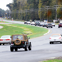
Other bridges are failing to keep up with growing traffic demands in a county booming with new residents and a growing number of tourists. On the bridges connecting Hilton Head Island to the mainland, for example, the average number of vehicles crossing has increased by about 7,700 vehicles per day from 2002 to 2014. That's a leap from 45,500 to 53,200 vehicles each day, according to the S.C. Department of Transportation.
The bridges may be insufficient to meet future traffic demands projected for the next 10 to 15 years -- never mind the traffic jams a hurricane evacuation will cause, according to a 2002 Beaufort County study.
Despite the apparent need, the S.C. Department of Transportation has not made plans for an expansion or repairs to an aging section of the Hilton Head Island bridges that has already exceeded its design life.
Beaufort County leaders are mulling a plan to pay for the design and engineering work for an expanded bridge through a bond issuance next year. Voters would have to sign off on the plan if county leaders decide to proceed.
For now, there is no funding, no timeline and no certain plans to make the improvements that local leaders agree must be done.
Map: A look at the bridges to be used during evacuations
HILTON HEAD BRIDGE UNDER STRAIN
On a regular day, a wreck on the Hilton Head Island bridges can cause a traffic jam that lasts hours. Last month, traffic stalled for an hour and fifteen minutes when a truck spilt building supplies on one of the bridges.
A hurricane evacuation would cause much longer delays.
"Imagine the worst traffic jam on the bridge and multiply it by five," said Hilton Head Emergency Management Coordinator Thomas Dunn. "That's what it would be like."
In the county's last mandatory evacuation -- for Hurricane Floyd in 1999 -- it took some Beaufort County drivers more than 20 hours to reach their destinations. The median amount of time was about eight hours, according to a post-Floyd survey by the National Oceanic and Atmospheric Administration.
Story continues after timeline
Past hurricanes and evacuations in Beaufort County
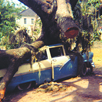
1893: This destructive storm known as The Sea Islands Hurricane of 1893 passed just 10 -15 miles west of southern Beaufort County on August 27, 1893. Surge levels reached up to 19.5 feet, killing an estimated 1,500 to 2,000 people on the barrier islands and lowlands from northern Georgia to Charleston. Most of those who died were freed slaves. Hurricane researchers believe the storm was a Category 3. It is still estimated as the third deadliest storm to hit North America.1940: This unnamed Category 1 hurricane made landfall in Beaufort County on August 11. A storm surge of about 10 feet hit outlying islands including St. Helena, Hilton Head and Daufuskie, leaving many homes destroyed. The Beaufort business district was flooded with two to three feet of water. Eight people died from the flooding on Lady's Island and the hurricane caused the deaths of 34 people in all and an estimated $6.6 million in damage, which has the buying power of about $112.5 million today.
1959: Hurricane Gracie was a Category 3 storm that made landfall September 29, 1959, just north of Beaufort County traveling through the St. Helena Sound. The storm caused severe damage in downtown Beaufort northward to Charleston from fallen trees, downed power lines and destroyed crops. Damage was estimated at $14 million in 1959 costs, equivalent to about $114 million today. Gracie killed 10 people in South Carolina and Georgia, including five locally. The storm came at low tide, preventing a massive storm surge, but still left much of the city of Beaufort flooded in three to four feet of water.
1979: Hilton Head Island evacuated for Hurricane David, but was spared major damage when the storm made landfall well south of the county. The hurricane caused some moderate damage and significant beach erosion in southern Beaufort County.
1985: The center of Hurricane Bob made landfall on Fripp Island in Beaufort County as a Category 1 storm on July 25 and moved northwestward through the county. There was minimal damage and no deaths from the storm.
1989: Hurricane Hugo is still the strongest hurricane ever recorded to make landfall in South Carolina. The Category 4 hurricane headed straight for Beaufort County, but swerved to make landfall September 22, 35 miles north of Charleston in McClellanville. It is estimated that there were 49 deaths directly related to the storm, 26 of which occurred in the U.S. Beaufort county residents, however, were largely spared from the storm. In total, damage estimates during Hugo for South Carolina total $5.9 billion.
1999: Hurricane Floyd caused more than 2 million people to evacuate from Florida to the Virginia border, creating traffic jams on major highways heading away from the coast. In Beaufort County, some residents idled in their cars for many hours while others ran out of gas before they could get out of town. A delayed decision by then Gov. Jim Hodges to reverse the state's interstate lanes played a role in his failed reelection bid. Ultimately, the Category 3 storm just brushed the county on September 15 before it changed course to North Carolina. Beaufort County reported $750,000 in damage from downed trees and damaged homes in the storm.
2004: The last evacuation for Beaufort County was in anticipation of Hurricane Charley in 2004, when then Gov. Mark Sanford called for a voluntary evacuation for low-lying areas. The Category 3 storm avoided the county, however, passing 50 miles off the coast before crashing into Myrtle Beach. There were no reports of local damage, but Charley caused devastation in Florida, causing 10 deaths and $15.4 billion in damage. It is the eighth costliest Atlantic hurricane on record.
Source: Beaufort County Hazard Mitigation report and the National Hurricane Center
 In this file photo taken during the Hurricane Floyd evacuation on Sept. 14, 1999, a member of the National Guard, right, directs evacuation traffic at the Cross Island Parkway's junction with William Hilton Parkway. | File/Staff photo
Hilton Head resident Mike Long left his Sea Pines home along with his wife Marie only to be quickly logjammed for hours in westbound traffic.
He remembers idling on the clogged Hilton Head bridges as he made the roughly 12-hour journey to his destination in Georgia.
"There was no traffic headed east at all and we wished that we could just ride on that side of the highway," Long said. "It was interesting though seeing all the cars packed full with belongings -- some with trailers piled high, and dog crates hung off the back of SUVs with dogs inside."
On the way, Long saw cars that had been abandoned after they ran out of gas, hotels completely booked for miles and people pulled over to sleep inside their cars.
Future evacuations should be somewhat better, said Beaufort County Emergency Management Commander Lt. Col. Neil Baxley.
Post-Floyd complaints of unreasonable traffic across the state led to improved evacuation routes and plans to reverse more lanes.
Three of the four lanes on the Hilton Head bridges will now be reversed, with one lane left open for emergency vehicles, Baxley said. And the six-lane U.S. 278 will have one lane reversed, so it too will have three lanes of westbound traffic.
But it still won't be quick. The Bluffton section of U.S. 278 will have no lane reversals. The three inbound lanes will remain closed to evacuees.
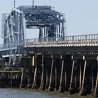
SHOWING ITS AGE
Beyond traffic concerns, one aging span of the bridges is more vulnerable to damage in a storm.
The oldest of the bridges' four spans was rated as structurally deficient by inspectors in 2008, though it is still deemed safe for daily traffic.
The three other spans were built in the 1980s. But the eastbound lane over MacKay Creek was constructed in 1956, likely with a design life of 50 years.
Inspectors reported that the older bridge showed cracks and some signs of corrosion in a 2010 report commissioned by the Town of Hilton Head Island and Beaufort County.
"This deterioration has potentially reduced some of the structure's capacity but does not impose an immediate risk of failure," the report read.
Inspectors recommended that officials schedule "significant rehabilitation and/or replacement in the near future."
It is now more than five years after that report and little progress has been made. Repairs fall to the S.C. Department of Transportation, which has not yet began plans for repairs.
It's a similar problem across the state. Only a fraction of the more than 1,000 bridges now deemed structurally deficient in South Carolina are repaired each year.
Efforts to increase the state pot of money for such repairs and speed up the timeline have been unsuccessful. The S.C. Legislature spent much of this past legislative session unsuccessfully grappling with the issue.
Meanwhile, the bridges to Hilton Head Island are the busiest roadways in Beaufort County and represent the only means of hurricane evacuation and re-entry for island residents.
"A hurricane would bring wind and water force beyond what designers might have planned because it's so far outside of normal," said Beaufort County director of engineering and infrastructure Robert McFee. "The force of water moving quickly in a storm surge can be incredibly destructive, especially for older, less robust bridges."
A NEW BRIDGE?
A more significant overhaul of the bridges have been considered by local officials to meet traffic demands.
But the project will be costly.
Proposals to either expand the bridges to six lanes or add a parallel bridge to the island would cost at least between $80 million and $160 million, according to a 2002 study commissioned by the county.
The county and state have invested millions to repair other aging local bridges.
The J.E. McTeer Bridge connecting Parris Island to Port Royal, for example, became the main evacuation route for the northern sea islands after voters approved a $34 million project to build a new span in 2011.
An environmental study for another critical new bridge began this year to replace the Harbor River bridge on U.S. 21 between St. Helena Island and Hunting Island. The current bridge, the only means of evacuation for people on both Hunting and Fripp islands, is more than 75 years old and structurally deficient. The $56-million project is set to begin in 2017, according to a DOT estimate.
Bridge projects cost tens of millions and maintenance can be just as much over the life of the structure.
The high costs have made crumbling infrastructure a problem all over the country, said Fabio Matta, a professor of civil engineering at the University of South Carolina.
"Especially for areas on the coast, this issue isn't going to go away; it's only going to get worse," Matta said. "Most bridges in South Carolina are now reaching 50 or 60 years old. We're being handed these bridges. Now we have to ask, 'What are we doing for the next generation?' Will they be safe?"
Follow reporter Erin Heffernan at twitter.com/IPBG_erinh.
Related Content:
- Study begins to replace aging Harbor River Bridge, June 27, 2015.
- Hilton Head's Karl S. Bowers Bridge showing its age, report finds, May 15, 2010.
- Major construction complete on new Beaufort River bridge, August 16, 2011.
Beaufort County bridges that must be used in future hurricane evacuations are old and may not be up to the task. | READ
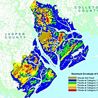
Beaufort County is so low-lying that a minor hurricane would cause major damage to property and prosperity. Flood plains make up 61 percent, or more 224,209 acres, of Beaufort County's land area. | READ

Almost three times the number of people live in Beaufort County today than in the 1970s. Yet the number of roadway miles used in an evacuation have mostly stayed the same. | READ
The biggest point of congestion in a Beaufort County evacuation now has planned lane reversals -- at least in some parts. | READ
Some hurricane experts say there's a big reason for Beaufort County's quiet spell when it comes to hurricane hits: sheer luck. | READ

A Beaufort woman and her family were planning on evacuating to Augusta. Hear how they ended up in Tennessee ... 18 hours later. | READ

NOAA's interactive tool lets you find out for each category of storm. | READ
This story was originally published August 20, 2015 at 2:40 PM with the headline "Bridges used in evacuations nearing end of their lives."