US 278 in Bluffton will not be reversed in evacuations
 In this file photo taken during the Hurricane Floyd evacuation on Sept. 14, 1999, traffic comes to a stand still on the bridges leaving Hilton Head Island. | File/Staff photo
The biggest point of congestion in a Beaufort County evacuation now has planned lane reversals -- at least in some parts.
In the next Beaufort County hurricane evacuation, vehicles leaving Hilton Head Island will travel for the first time in an additional lane from the Cross Island Parkway to Moss Creek Drive. One eastbound lane will be reversed.
But from that point, lane reversals end.
Once drivers hit U.S. 278 at the bottom of the bridges just beyond Moss Creek Drive in Bluffton, they will be limited to three westbound lanes. The three eastbound lanes will not be reversed.
Emergency management officials say the state decided it would not be efficient to reverse all lanes of U.S. 278 the entire way to Interstate 95 because it would create a bottleneck effect and require too many emergency workers to oversee, said County Emergency Management Commander Lt. Col. Neil Baxley.
"If you open those lanes, then yes you get more roadway (for vehicles) to move on. But it creates a choke point when the lanes narrow at the county line," said Baxley. "It wouldn't work."
At the intersection of U.S. 278 and U.S. 170 just before the county line, one lane of traffic will be directed to U.S. 170 towards S.C. 462 before the roads narrow to two lanes. The other two lanes will continue on U.S. 278 until they are directed north to either I-95 or U.S. 17.
Drivers get frustrated as they stare for hours at open lanes they are not allowed to use. It has happened in previous evacuations.
"You saw these empty lanes and you're dying in traffic, thinking, 'Why can't I just drive over there?' I was afraid my engine was going to give out," said Hilton Head Island resident Todd Offen who evacuated during Hurricane Hugo in 1989.
For him, a lack of reversed lanes on the Hilton Head Island bridges was the worst part. He's optimistic about an additional lane on the bridges during the next evacuation.
"I hope some lane reversals will make it better than it has been," he said.
The state revised its evacuation plan to include lane reversals after a difficult evacuation for Hurricane Floyd in 1999.
Now coastal routes on Interstate 26, U.S. 501 and S.C. 544 will be reversed in addition to the two primary Beaufort County evacuation routes on U.S. 278 and U.S. 21.
"We don't want another Floyd debacle," Baxley said. "I don't think we'll get one."
Follow reporter Erin Heffernan at twitter.com/erinheff.
Related Content:
- Beaufort County officials say US 278 construction will not affect evacuation, May 31, 2012
- State, local agencies to hold hurricane evacuation exercise, June 9, 2015
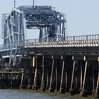
Beaufort County bridges that must be used in future hurricane evacuations are old and may not be up to the task. | READ
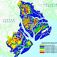
Beaufort County is so low-lying that a minor hurricane would cause major damage to property and prosperity. Flood plains make up 61 percent, or more 224,209 acres, of Beaufort County's land area. | READ

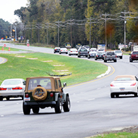
Almost three times the number of people live in Beaufort County today than in the 1970s. Yet the number of roadway miles used in an evacuation have mostly stayed the same. | READ
The biggest point of congestion in a Beaufort County evacuation now has planned lane reversals -- at least in some parts. | READ

Some hurricane experts say there's a big reason for Beaufort County's quiet spell when it comes to hurricane hits: sheer luck. | READ

A Beaufort woman and her family were planning on evacuating to Augusta. Hear how they ended up in Tennessee ... 18 hours later. | READ

NOAA's interactive tool lets you find out for each category of storm. | READ
This story was originally published August 20, 2015 at 2:33 PM with the headline "US 278 in Bluffton will not be reversed in evacuations."