Update: Tropical Storm Beryl picks up speed. Rainy days ahead in the Lowcountry?
This story was updated on Friday morning after Beryl became a hurricane. Read that story by clicking here.
The first month of hurricane season was quiet, but July is shaping up differently as meteorologists eye two separate storms brewing in the Atlantic.
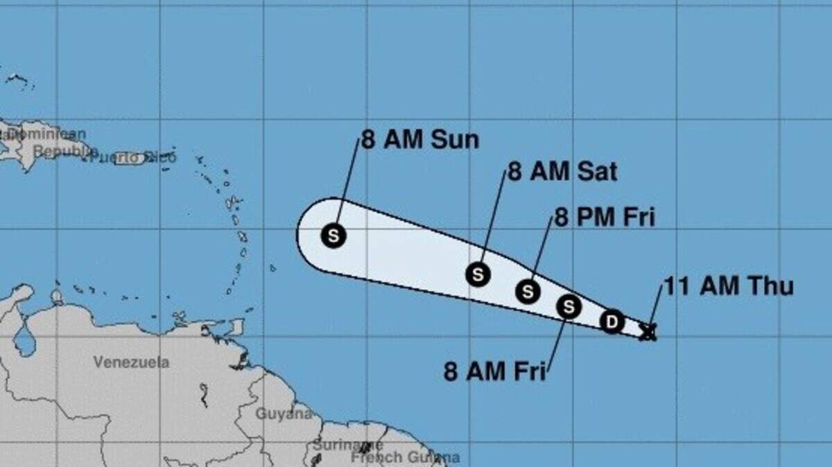
The National Hurricane Center reported at 2:30 p.m. Thursday that Tropical Depression 2, located between the Cabo Verde Islands and the Lesser Antilles, had strengthened to Tropical Storm Beryl.
Meteorologists, who also are watching an area of potential development southwest of Bermuda, don't expect either system to directly threaten land.
Tropical weather being pushed from the Atlantic to the Gulf of Mexico could mean a greater chance of rain and stronger surf on the East Coast for the coming weekend, according to AccuWeather.
The threat for severe weather across the Lowcountry appears low, although there is a threat of isolated flooding during times of heavy rainfall, according to the National Weather Service in Charleston.
Beaufort County could see 1 to 1.5 inches of rain over the next week — most of that on Sunday, the weather service said.

Tropical outlook
Hurricane Center meteorologists watching a band of showers and thunderstorms southwest of Bermuda say the potential for a tropical storm forming there has diminished.
It's still possible that there will be some development when the system moves between Bermuda and the East Coast.
The 2 p.m. Thursday forecast gave the area a 30 percent chance of becoming a tropical storm over the next 48 hours and a 40 percent chance over the next five days.
Meanwhile, Tropical Storm Beryl, located between the Cabo Verde Islands and the Lesser Antilles, had maximum sustained winds estimated at 40 mph with higher gusts, according to the National Hurricane Center.
Meteorologists predict the storm will be torn apart by upper-level winds as it approaches the Lesser Antilles in the next three to four days.
At the end of May, even before hurricane season started, Subtropical Storm Alberto made its way through the Gulf of Mexico.
June saw no named storms for the first time in several years.
The next storm that develops will be named Chris.
Beaufort County forecast
Thursday
Partly sunny with a chance of showers and thunderstorms. Highs in the upper 80s. East winds 5 to 10 mph. Chance of rain 40 percent.
Thursday night
Mostly cloudy. A slight chance of showers and thunderstorms in the evening. Lows in the mid-70s. East winds 5 to 10 mph. Chance of rain 20 percent.

Friday
Partly sunny. A slight chance of showers and thunderstorms in the morning, then a chance of showers and thunderstorms in the afternoon. Highs around 90. Northeast winds around 5 mph, becoming southeast in the afternoon. Chance of rain 30 percent.
Friday night
Partly cloudy. A chance of showers and thunderstorms, mainly in the evening. Lows in the mid-70s. South winds around 5 mph, becoming southwest around 5 mph after midnight. Chance of rain 30 percent.
Saturday
Showers and thunderstorms likely. Highs in the upper 80s. North winds around 5 mph, becoming east in the afternoon. Chance of rain 60 percent.
Saturday night
Showers and thunderstorms likely. Lows in the mid-70s. Chance of rain 60 percent.
Sunday
Showers and thunderstorms likely. Highs in the mid-80s. Chance of rain 60 percent.
Sunday night
Mostly cloudy with a chance of showers and thunderstorms. Lows in the mid-70s. Chance of rain 50 percent.
Monday
Partly sunny with a chance of showers and thunderstorms. Highs in the upper 80s. Chance of rain 50 percent.
Monday night
Partly cloudy with a slight chance of showers and thunderstorms. Lows in the mid-70s. Chance of rain 20 percent.
Source: National Weather Service in Charleston
This story was originally published July 5, 2018 at 11:54 AM.