New interactive storm-surge map helps residents see potential flood risks

A new interactive map is allowing coastal residents to see what it would take for a hurricane's storm surge to reach their own backyards.
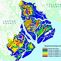
The national map, released Friday by the National Oceanic and Atmospheric Administration, shows how far a storm surge would reach, and to what height, in the worst-case scenario of each category of hurricane.
In a Category 1 hurricane, some areas of the county could see storm surges up to six feet high. A few spots along the May River could be inundated with more than nine feet of water. And a Category 2 storm could leave much of the county underwater.
Local emergency management workers say the information isn't new. It's simply been pulled from other models and repackaged into one map, making it easier for residents to use it on their own.
"I think it'll help bring it home when we tell the public (a storm) is serious," said David Zeoli, deputy director of Beaufort County emergency management.
However, Zeoli said he expects some people may be worried after using the map for the first time. He cautioned that the map illustrates the most severe results possible.
"This is at high tide, the highest winds, the worst angle the storm could come in at," he said, adding that the county would likely face a mandatory evacuation in the event of a hurricane.
Although the new map is helpful, Zeoli said, Beaufort County emergency management uses real-time information when storms approach. For the first time this year, those projections would have included surge maps from the National Hurricane Center, tailored to each impending storm.
Nonetheless, Town of Hilton Head Island emergency management coordinator Thomas Dunn said he is looking forward to using the new map to inform residents.
"You really get a sense of, wherever you live, how this storm surge could impact you," he said. "It's an excellent educational tool."
Mapping your storm surge risk
Visit the Storm Surge Inundation map by clicking here. Zoom in to your neighborhood, then choose a storm strength category to model.
Follow reporter Rebecca Lurye on Twitter at twitter.com/IPBG_Rebecca.
Beaufort County is so low-lying that a minor hurricane would cause major damage to property and prosperity. Flood plains make up 61 percent, or more 224,209 acres, of Beaufort County's land area. | READ
More related content:
- Experimental storm-surge maps to accompany NOAA hurricane projections in 2014, beyond, February 5, 2014
- Hurricane Center
This story was originally published November 7, 2014 at 6:03 PM with the headline "New interactive storm-surge map helps residents see potential flood risks."