Update: As Florence moves closer to Lowcountry, experts urge residents to start preparing
This story was updated at 5 p.m. Friday.
Florence weakened from a hurricane to a tropical storm on Friday morning, but meteorologists expect the storm to strengthen over the weekend.
And the National Weather Service is advising South Carolina residents and visitors to keep their eyes on the storm’s location.
“This weekend is a good time for interests along the U.S. East Coast to review their hurricane plan,” a weather service bulletin said at 5 p.m. Friday.
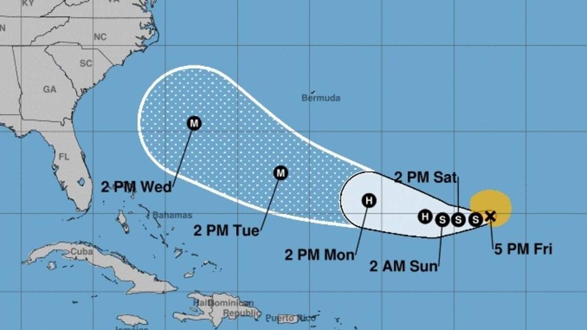
Neil Dixon, meteorologist with the National Weather Service in Charleston, said the current forecast track puts the storm between Bermuda and the Carolinas.
“It’s still a long way out, but that position is concerning to anybody living on the East Coast of the U.S.,” Dixon said.
“We will know more this weekend, especially as the storm strengthens,” Dixon said.
Florence forecast
Late Friday afternoon, Florence was in the Atlantic Ocean moving west at 8 mph, according to the National Hurricane Center.
The storm is expected to continue moving west for a few days and then begin to turn toward the west-northwest by the end of the weekend, an advisory from the hurricane center said.
Florence’s maximum sustained winds were 65 mph, but the forecast said strengthening was expected over the weekend.
Rip currents and flooding
Even long before Florence approaches land, Beaufort County and coastal Jasper County will start to see effects of the storm’s power, according to the National Weather Service in Charleston.
A hazardous weather outlook warns of the moderate risk for rip currents this weekend in southeastern South Carolina and Georgia.
Also, increasing swells plus the moon at its perigee — the point in its orbit when it’s closest to Earth — mean the Lowcountry should expect coastal flooding during the evening tide.
A coastal flood advisory is in effect from 5 to 8 p.m. for Beaufort County.
“More significant coastal flooding is possible during the middle of next week ... dependent on the track of Florence,” the weather service outlook said.
Storm preparations
Even though the storm’s track isn’t certain, Lowcountry residents should prepare for the possibility of landfall, Dixon said.
“Right now is a great time to either review your hurricane plan or create one,” he said. “Make preparations to get your home in order and be thinking ... about where you are going to go in case evacuations are ordered.”

Other tropical activity
Meteorologists also were watching other areas of tropical activity in the Atlantic Ocean on Friday afternoon:
- A low-pressure system just off the coast of Africa strengthened into Tropical Depression Eight. Maximum sustained winds were 35 mph, and it was moving west at 10 mph. If the storm grows strong enough to be named, it would be Helene.
- On the west coast of the Cape Verde Islands, Tropical Depression Nine formed. Maximum sustained winds were 35 mph, and it was nearly stationary. If the storm grows strong enough to be named, it would be Issac.
- A trough of low pressure also is producing showers and thunderstorms over the western Atlantic, southwest of Bermuda. Formation chances there were put at 10 percent over the next 48 hours and 20 percent over the next five days.
Meanwhile, Tropical Depression Gordon was over Arkansas and moving north at 7 mph. Flash flood watches were in effect.
This story was originally published September 7, 2018 at 10:32 AM.