Eyes on Gordon and Florence: What do 2 tropical storms mean for Beaufort County?
After a mostly quiet hurricane season, the tropics have sprung to life, but there’s no reason for Beaufort County residents or visitors to panic, experts say.
“There’s not going to be any direct impact” on the Lowcountry from the two currently active storms, said meteorologist Emily McGraw of the National Weather Service in Charleston.
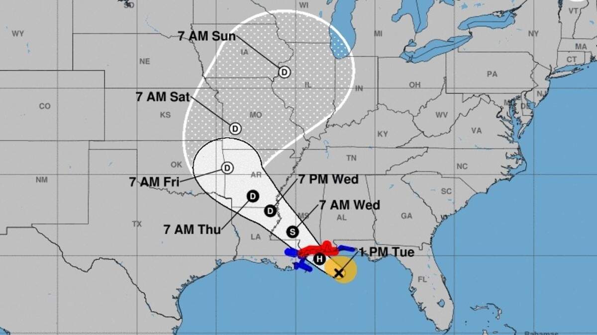
As of 2 p.m. Tuesday, Tropical Storm Gordon was located in the Gulf of Mexico and moving northwest at 15 mph. Its maximum sustained winds were 65 mph, according to the National Hurricane Center.
It was expected to become a hurricane shortly before striking land along or near the Mississippi coast late Tuesday, the hurricane center’s forecast said. The storm was expected to slow down and move inland on the Mississippi or Alabama coast by early Wednesday.

Heavy rainfall from Gordon likely will affect an area from the Louisiana coast through the Florida Panhandle and inland along the storm’s track, according to the hurricane center.
Rainfall totals could reach as high as 12 inches in some areas through late Thursday, the forecast said.

Florence was upgraded to hurricane status as of the hurricane center’s 11 a.m. update. It was moving west-northwest at 12 mph in the Atlantic Ocean and was expected to turn more toward the northwest on Friday. Its maximum sustained winds were 75 mph.
“Whether or not Florence remains a danger to only shipping interests or threatens land will depend on how far west the storm tracks,” Accuweather reported.
Meteorologists also are watching an area off the Cabo Verde Islands that could become a tropical depression later in the week. As of 2 p.m. Tuesday, formation chances were 30 percent within 48 hours and 80 percent within five days.
The next storm that forms will be named Helene.
Lowcountry coastal hazards
Beaufort County and coastal Jasper County are included in an area covered by a hazardous weather outlook, according to the National Weather Service in Charleston.
There is a moderate risk of rip currents through Tuesday evening, the alert said.
Also, it warns that coastal flooding may be an issue later this week. Tide levels are expected to rise because of the lunar perigee and onshore winds starting with the evening high tide on Friday.
The lunar perigee is when the moon is in its closest position to Earth, according to Earth Sky.
There’s only a slight chance of rain in Beaufort County for most of the week, the forecast indicates.
“The weather will be pretty seasonable for this time of year,” McGraw said.
Beaufort County forecast
Tuesday
Partly sunny. A slight chance of showers and thunderstorms this morning, then a chance of showers and thunderstorms this afternoon. Highs in the upper 80s. East winds 5 to 10 mph. Chance of rain 40 percent.
Tuesday night
Mostly cloudy with a slight chance of showers and thunderstorms. Lows in the mid 70s. East winds 5 to 10 mph. Chance of rain 20 percent.
Wednesday
Partly sunny. A slight chance of showers and thunderstorms in the morning, then a chance of showers and thunderstorms in the afternoon. Highs in the upper 80s. East winds 10 to 15 mph. Chance of rain 30 percent.
Wednesday night
Mostly cloudy in the evening, then becoming partly cloudy. A slight chance of showers and thunderstorms. Lows in the mid 70s. East winds 5 to 10 mph. Chance of rain 20 percent.
Thursday
Partly sunny with a chance of showers and thunderstorms. Highs in the upper 80s. East winds 10 to 15 mph. Chance of rain 40 percent.
Thursday night
Partly cloudy with a slight chance of showers and thunderstorms. Lows in the mid 70s. Chance of rain 20 percent.
Friday
Partly sunny with a chance of showers and thunderstorms. Highs in the upper 80s. Chance of rain 40 percent.
Friday night
Partly cloudy with a chance of showers and thunderstorms. Lows in the mid 70s. Chance of rain 40 percent.
Saturday
Mostly sunny with a chance of showers and thunderstorms. Highs in the upper 80s. Chance of rain 40 percent.
Saturday night
Partly cloudy with a chance of showers and thunderstorms. Lows in the mid 70s. Chance of rain 40 percent.
Sunday
Mostly sunny with a chance of showers and thunderstorms. Highs in the upper 80s. Chance of rain 30 percent.
Sunday night
Partly cloudy with a slight chance of showers and thunderstorms. Lows in the mid 70s. Chance of rain 20 percent.
Source: National Weather Service Charleston
This story was originally published September 4, 2018 at 9:04 AM.