Hot spot in Beaufort? 105. Temps hit 100 on Hilton Head. When will heat wave end?
It will be hotter than Hades again on Sunday, even for coastal South Carolina.
But, thank God, a break in the heat wave is on the horizon.
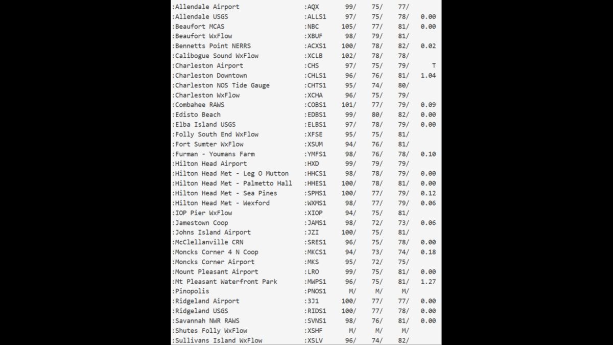
On Saturday, temperatures cracked 100 degrees across Beaufort County.
The Marine Corps Air Station in Beaufort recorded the highest temperature, 105 degrees, according to the National Weather Service in Charleston.
But Calibogue Sound, famous for its sunset view of Harbour Town Lighthouse on Hilton Head, was not far behind at 102.
The temperature hit 100 degrees at Sea Pines and Palmetto Hall plantations on Hilton Head.
Is the heat wave over?
Almost.
Another heat advisory is in place until 7 p.m. Sunday, with a high temperature of 98 predicted and a heat index of 112, according to the National Weather Service.
The heat index, also known as the “feels like” temperature, measures how hot the air actually feels when humidity and the temperature are combined.
But isolated severe thunderstorms, which are expected to develop Sunday afternoon, will be the beginning of a cool-down, said Brandon Black, the Weather Service’s lead meteorologist in Charleston.
High temperatures may return for a spell later in the week, “But it definitely won’t be as bad as it’s been,” Black said.
Beaufort will see a high of 92 on Monday, 91 degrees on Tuesday, 93 on Wednesday and 95 on Thursday. Lows will be in the 70s. Thunderstorms are likely Monday and Tuesday. The forecast for Hilton Head is similar.
When did the heat wave start?
High temperatures flirting with 100 degrees, and in some instances breaking triple digits, began around July 4.
How hot did it get?
Temperatures have been in the mid- to upper-90s from Savannah to Charleston. Charleston recorded a temperature of 100 on Thursday. It was the first time the city has seen a triple-digit temperature in seven years.
The Marine Corps Air Station at Beaufort reported a temperature of 105 Saturday. The low was 77. The high temperature was 102 at the base on Thursday, and 100 degrees on Friday, according to the National Weather Service.
Savannah also hit 100 degrees a few times, Black said.
Temperatures have been five to six degrees warmer than usual. Typically, right along the coast, high temperatures this time of year are around 90 degrees and a few degrees higher farther inland, Black said.
Why the heat wave?
A pattern of strong high pressure called the Bermuda High decided to park over the East Coast. Most of the time, the system is over the Atlantic Ocean, near Bermuda, from early summer to early fall, Black said. But it moves around and this summer it shifted to the west. “It’s kind of been sitting over us a little bit closer,” Black said.
Thunderstorms coming?
There’s a “marginal” chance the Sunday afternoon storms will bring a risk of strong damaging wind gusts to 60 mph, the Weather Service said. There’s also the potential for isolated flooding.
This story was originally published July 12, 2026 at 10:43 AM.