A USC lab was built on a Beaufort Co. barrier island decades ago. Now it’s in the water
Hannuman Bull used to live largely alone on a barrier island off the South Carolina coast.
He’d wake up to a cup of coffee, descend from the stilted lab building he stayed in and walk his dog, Jake, on the desolate Pritchards Island.
For three turtle nesting seasons over three years, Bull served as the island’s manager. Pritchards Island had a functioning laboratory back then, a raised wooden structure with ocean views. It was tucked away, surrounded by live oaks and palmettos, only the sound of crashing waves interrupting what for many was an undisturbed respite.
It was a place where researchers and students stayed to study the island’s ecosystems and monitor threatened loggerhead sea turtles. Bull was in charge of a radar system measuring ocean currents and waves.
Almost 15 years have passed since Bull left the lab. Now, it’s abandoned. But what lies beneath the building tells a larger story; one where the lab unwittingly became a study in itself.
Pritchards Island is being swallowed by the ocean, primarily because of the coast’s natural life cycle but also from nearby development and rising seas. While many say the island’s fate is expected, some have concern about how quickly it’s disappearing.
“When I was last there, there was one last dune in front of the facility, but as far as I understand, that’s been washed away now,” Bull recalled, nearly 1,000 miles away in his Boston home.
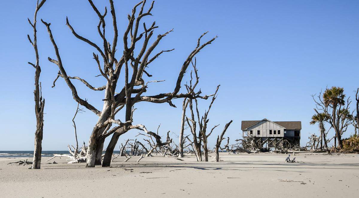
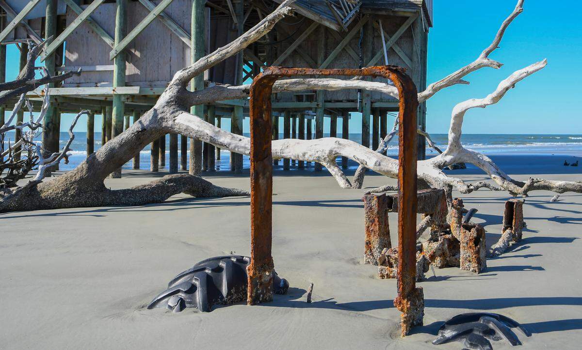
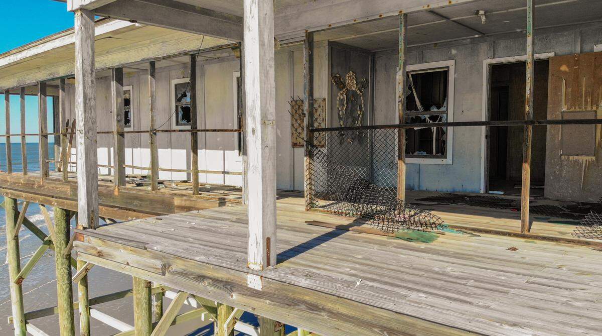
He’s right. The ocean surf is now underneath the stilted building. Less than 30 years stand between about 300 yards of dune that have been eroded from in front of the lab when it was built in 1994. Horizontal beams, enclosing the lower perimeter of the building, used to sit atop the sand. Now, they’re elevated about 10 feet from the ground, and even in low-tide, water laps at the barnacle-encrusted stilts below.
Scientists said this would happen. Sand and sediment would shift as waves and wind crashed into the island, swelling and shrinking its size. That’s the point of barrier islands like Pritchards. Erosion is inevitable, especially on the northeast corner — exactly where the lab sits.
What’s vexing is what scientists didn’t know: How quickly Pritchards Island and the lab would erode.
They’re going fast. And with it, scientific research efforts have been washed away.
‘We blame it on Fripp’
Pritchards has never been like other barrier islands nearby because nobody has ever tried to manipulate it.
It’s never had a sea wall like the rock revetment at Fripp Island. It doesn’t have the steel sheet pile groin structures running up the shore to stabilize it like Hunting Island. It’s not had tons of sand packed onto it for renourishment.
In fact, keeping Pritchards Island in its natural state, used only for research purposes and barring other development, were the conditions Atlanta businessman Philip Rhodes gave when he donated the island to the University of South Carolina in 1983.
That meant the island would take natural hits.
Barrier islands are re-exposed sandbars that lay parallel to the main shoreline and serve to protect it from hurricane and storm destruction. Built up sand dunes and beaches are a defense system, and the shore-facing side protects what are often marshes or maritime forests behind it.
When waves and wind beat against the front end of the barrier island, they pull sand away and carry it into the ocean, depositing slightly south of where it was before. It’s a process called longshore transport.
Essentially, barrier islands are constantly receding, said Joe Staton, University of South Carolina Beaufort biology and marine science professor and the natural sciences department chair.
“The front ends are being eroded and the back ends are being built on,” Staton said. “Overtime, barrier islands kind of look like they’ve marched backward to the mainland but the mainland is kind of marching from them at the same time.”
But Pritchards has eroded so much that ancient oyster beds and mud banks sprouting with Spartina grass are in the surf zone, when they used to be hidden away in the creeks back in the salt marshes. It’s hard to tell the age of the banks. They could be 200 years old, Staton said, or they could be closer to 2,000.
The combination of climate change, Mother Nature and development on nearby Fripp Island are suspected of causing troubles at Pritchard’s Island.
“We blame it on Fripp,” Robert Morris, a Beaufort native who can navigate a trip to Pritchards with veteran ease, said with a laugh.
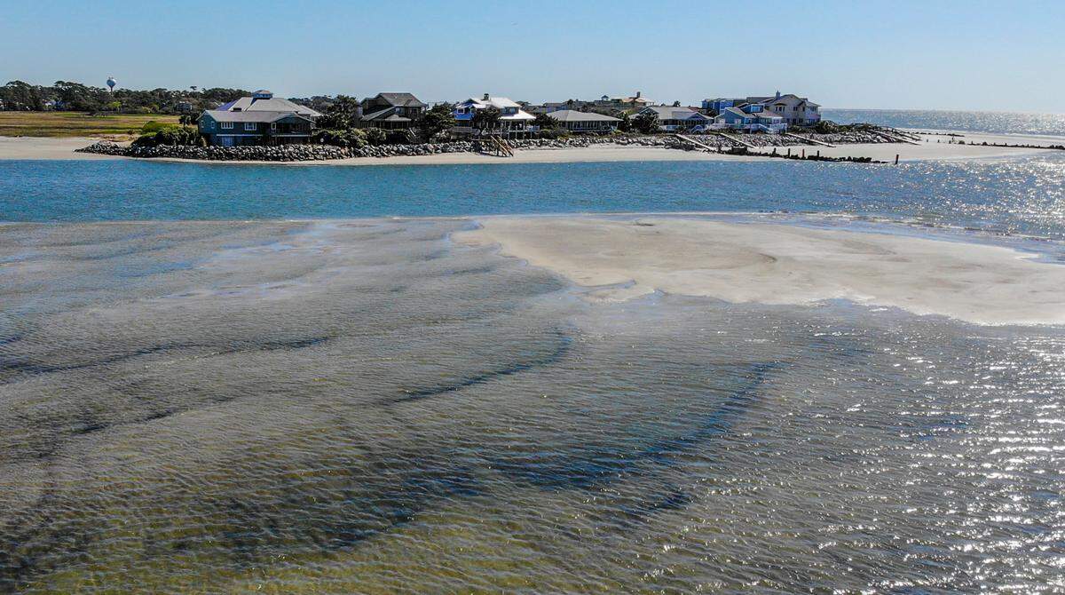
With a turned back, staring at Pritchard’s desolation, it’s easy to forget Fripp Island, a gated community north of Pritchards that’s dotted with significant pastel homes. But the two islands, stark as night and day, are nearly within walking distance across a sandbar during low tide. About 100 yards away, a skilled kayaker or swimmer can challenge the current.
Morris isn’t wrong. The rock revetment built on Fripp Island was constructed to preserve the land. It’s actually grown from sand eroding from Hunting Island, traveling across the inlet and attaching to the ocean side — what’s called an accreting barrier island.
Once a structure or development is put in place to protect a coastal or island property losing sand, coastal changes can take on a different, more urgent meaning, said Jessie White, the Coastal Conservation League’s south coast office director.
“Now somebody’s investment is at stake,” White said. “And it usually leads to further attempts to manipulate the island, the island geography itself in order to protect the structure of the human footprint.”
No longer is it about accepting the sacrificial nature of a barrier island. White said focus instead shifts to protecting capital, leaving behind what’s in its wake.
Such is the man-made sea wall that protects Fripp. It destabilizes longshore transport and in turn what’s south of it: Pritchards.
Six-decade perspective
Before Morris could string together full sentences, he was walking Pritchards Island with his family.
He wasn’t interested in erosion then. Not because it wasn’t blatantly happening, but he was otherwise occupied with a fishing line or making his way to the end of the island.
“When I was a little boy, the beach was just huge,” Morris, 66, said. “You could never walk from one end to the other. You could do it every day now.”
And every day brings something different. Sometimes the beach elevation on the north end can change by feet day to day because of changing tides, he said.
Over a decade ago, when Morris and his wife, Abby, began Pritchards’ sea turtle conservation program, a piece of driftwood at the edge of the island’s trees had between 50 and 75 yards of sand between it and the ocean.
Now it’s in the surf.
So are the foundations of houses erected in the 1960s, once impossible to find because they were shrouded by forest.
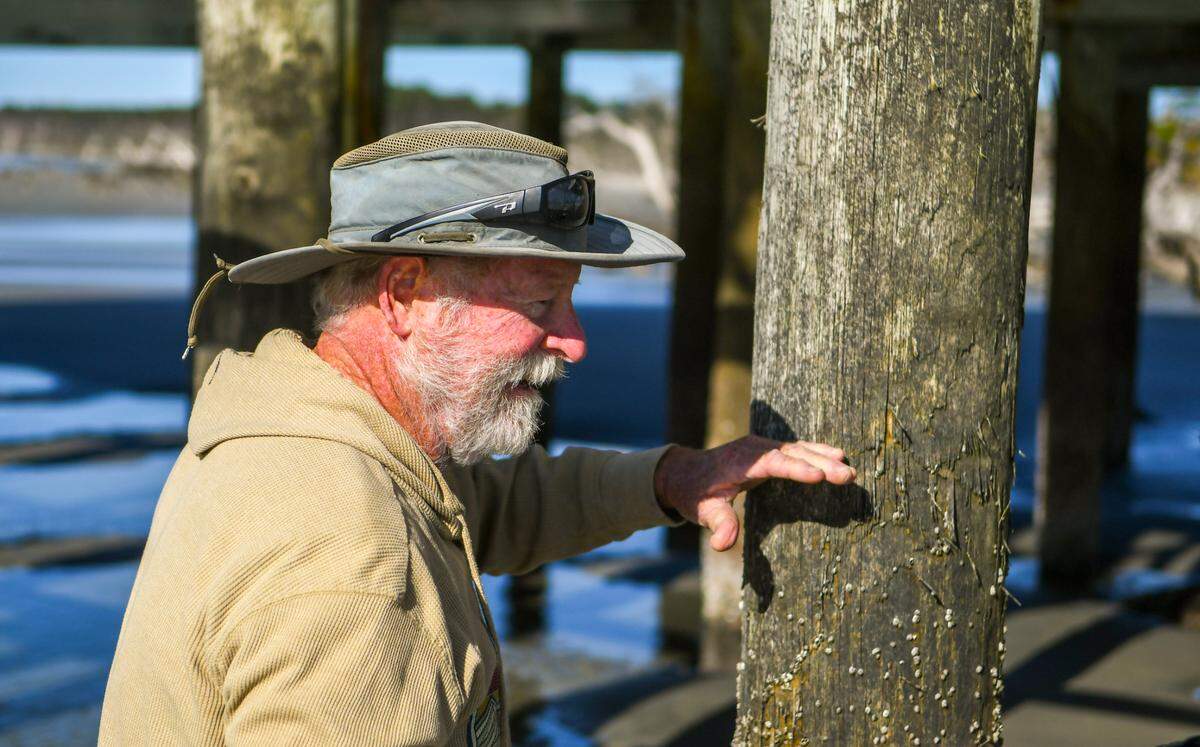
On a blustery day in early April, the Morrises point out the high-tide line. It’s nearly 6 feet up the lab’s stilts, which were covered in sand almost three decades ago.
Deflated foil balloons, a rogue flip-flop and a satellite dish are among the morning’s litter clean-up. Other things can’t be pulled from the island so easily. A sizable tractor, thick power lines and the dilapidated Pritchards lab itself.
Bark-bare oaks, dry as a bone and ivory-white like the sand, jut from the ground, waiting for the tide to roll in. It comes in fast. Rushing a short distance, nearly crowning the remaining palmettos standing behind the lab building. North of the lab, unused dock pilings stick up in soft, rippled sand. South of that, above the high-tide line, is where the sea turtles nest, Abby Morris said.
No one can pinpoint the exact year, but once the lab shuttered, the Morrises soon picked up where the work left off. Along with other volunteers, Abby and Robert protect and monitor the sea turtles’ nesting activity, making a boat ride that requires snaking through estuaries several times a week.
How long until the shoreline in front of the Pritchards lab is perpetually covered? Robert Morris, who joked his decades visiting the island earned him a PhD in erosion, estimated two years.
Shorelines are a way to measure erosion. Fripp Island’s extends appreciably farther into the ocean that Pritchards.
“We should be parallel to Fripp,” he said, dragging his finger in a line across the two shorelines.
Watching the island rapidly erode is for Robert Morris both sad and interesting, he said. But Rob Young, geology professor and program director for the study of developed shorelines at Western Carolina University, sees it differently from Morris.
“When people see the rapid change in a place like that, people shouldn’t be sad, they should appreciate it for what it is,” Young said. “The fact that the shoreline is changing very rapidly, and some of the forest is dying back, is to me, as a scientist who studies the evolution of these systems, really beautiful. It’s what should be happening.”
That’s not to say human-driven global warming and rapid sea level rise further affecting Pritchards and other coastal areas are OK, Young added. They’re not. And people need to combat climate change, he said.
Still, Young can appreciate Pritchards for what he calls it. An “unchained” island.
An experiment in itself
When Staton came to the University of South Carolina Beaufort in 2003, he was, at first, tangentially connected to Pritchards. The lab building was up and functioning, monitoring threatened loggerhead sea turtles between May and October.
There were guided walks to search for sea turtles on the weekends. Artists who would paint in the mornings. Bull recalled a small camp of people living on the island, grandfathered into the deal Rhodes made with USC.
Occasionally, Staton took students out on field trips, a journey only made by boat when the tide was just right. Sometimes he’d cook for his students “knock-off” lasagna with premade Italian meatballs in the lab’s kitchen.
“I mean, no one ever complained about cooking. It was just kind of like camp-style cooking,” Staton said, taking a long pause. “It was a neat place and I’m sorry it’s not with us anymore. But you know as they say, tide and time waits for no one.”
For years, the university received money from the state and a private donor to keep research efforts afloat. It paid to house a manager, upkeep research efforts and the lab itself.
About a decade after Stanton began at USCB, Pritchards Island’s money was drying up, but it was beach erosion, battering the lab, that made it unsafe to work in.
The Pritchards Island lab was shuttered and research ended. The very space intended to carry out on-the-ground research about the island’s sea turtles and wave patterns was succumbing to the ocean.
“We tried to do as much as we could to keep it running as long as possible,” Staton said. “But it became kind of clear that it was only going to have a limited lifespan based on the changes in the beach there.”
Did the people involved with initial construction know the lab couldn’t be built to last? Staton can’t say for certain. He wasn’t there but contends the erosion happened “faster than expected.”
“We have enormous tides in this area, but the amount of sea level rise over time, yes, it’s affecting everything, including Pritchards Island,” he said.
But other nearby islands aren’t experiencing the same kind of recession, because of efforts to build-up or protect them. The nature of longshore transport is at stake.
And it’s clear from the lab on stilts, which once was separated from the ocean by 300 yards of dunes.
“It serves as a really strong case study on how barrier islands move, because it ended up being in the water,” White said. “We know the evolution now. And we know better than to site anything else in harm’s way.”
The future of Pritchards
Young still uses Pritchards to illustrate to his students the differences between barrier islands.
A diverse ecosystem still runs rampant on the island. Rattlesnakes. Raccoons. Ghost crabs. A bobcat family. And loggerhead turtles, when they nest.
In the grand scheme of nature and science, Pritchards isn’t actually the outlier. Like Young said, the island’s done what it’s supposed to. It serves as the control in the experiment of barrier islands.
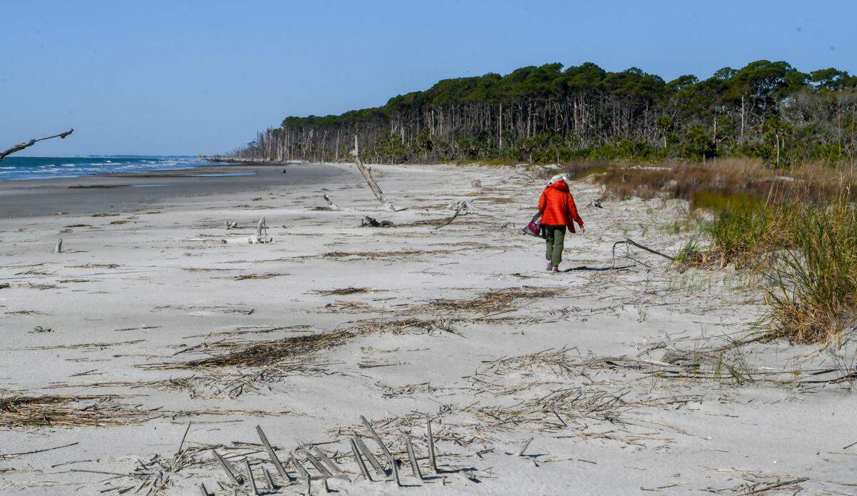
It’s a place Young, despite the research center’s closure, takes solace in. No interference from humans or development. It’s a spot he can go to get away from the hustle and bustle and soak up nature the way it should be.
For Bull, Pritchards is a distant memory, revived by a years-old video he stumbled on. For Staton, it’s a potential teaching grounds where there’s interest to start up a program again. And for the Morrises, a dedicated act of love to conserve the loggerhead sea turtles.
“U.S. shorelines are pretty much built out from Saco Bay, Maine, to Padre Island, Texas,” Young said. “Still having some places that are refugia where you can go and be by yourself, most of the time, there aren’t that many places left like that.”
Pritchards is one of the very few.
This story was originally published April 18, 2022 at 5:00 AM.